Official Archive Record
Case File CF-0047
The Piri Reis Map Mystery
Also known as: Piri Reis world map, 1513 Piri Reis map, Piri Re'is map, Piri Reis chart
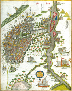
The Piri Reis Map is one of those historical artifacts that feels like it should be locked in a glass case with dramatic music playing behind it. It is real. It is old. It is detailed. And depending on who you ask, it may show knowledge that should not have existed in 1513.
What Happened
The map was drawn in 1513 by Piri Reis, an Ottoman admiral and cartographer. Only part of the original map survives today. The remaining section shows portions of the Atlantic world, including the western coasts of Europe and Africa, parts of South America, and islands in the Atlantic.
That alone is interesting. The map was made only a few decades after Columbus reached the Americas, during a time when European and Ottoman mapmakers were trying to understand a world that had suddenly gotten much larger.
But the mystery comes from the lower part of the map. Some writers and alternative-history researchers have claimed that it shows Antarctica before Antarctica was officially discovered. Even stranger, some argue that it shows the coastline of Antarctica without ice, suggesting that the map copied from much older sources created by a lost advanced civilization.
Mainstream historians are not convinced. The more accepted explanation is that the disputed landmass is likely a distorted version of South America, mixed with mapmaking errors, assumptions, and older geographic ideas. Early maps often stretched, bent, repeated, or imagined coastlines as cartographers tried to fill in the unknown.
Why It Matters
The Piri Reis Map matters because it sits at the crossroads of real history and speculative history. The artifact itself is not fake. Piri Reis was a real person, and the map is a real surviving document from the early 1500s.
The debate is about interpretation.
Was Piri Reis simply using the best maps and reports available in his time? Was the strange southern coastline just a mistake? Or did he copy from older source maps that preserved knowledge from sailors or civilizations we have forgotten?
That is what keeps the mystery alive. A map can be evidence, but it can also be a mirror. People see the same lines and come away with completely different stories.
T Funk Take
The Piri Reis Map is interesting because all of the explanations feel plausible. I do not think it is unfathomable that mapmakers filled in unknown gaps with something artistic. These maps were works of art, treated with more care than an old atlas in a car’s center console or a modern map on a phone. They had to be drawn and painted by hand.
And what information is more important than knowing where you are?
If the culture of the time had deep reverence for maps, and treated them as seriously as we treat our phones today, is it really that hard to imagine that older maps from faraway lands may have been saved, copied, and passed down? Could some of those source maps have come from before major shifts in Earth’s climate or coastlines?
Maybe later mapmakers copied what they saw without fully understanding where it came from. Maybe they filled in the unknown with art. Maybe they were wrong. Or maybe, in some places, they were more accurate than we expected them to be.
Until the map tells us what it was copying from, this one stays disputed in the archive.
Sources & Further Reading
-
The Piri Reis World Map (1513)
UNESCO Memory of the World
View Source -
Piri Reis World Map — Memory of the World Nomination
UNESCO / Topkapı Palace Museum
View Source -
Map of Piri Reis
Republic of Türkiye Ministry of Culture and Tourism
View Source